Showing posts with label Scenic Landscapes. Show all posts

Visit southwestern orchards in Summer

Orchards in Vinh Long: Vinh Long has long been famous for its orchards, which offer all kinds of fruit in all four seasons. The most famous fruits here are Binh Minh pomelo, Binh Hoa Phuoc rambutan, Tam Binh orange, Ri 6 and Chin Hoa durian, sugar tangerine and Hoa Loc and Cat Chu mango.

 
Lai Thieu orchards: Located about 20km from Ho Chi MinhCity, Lai Thieu is the home to vast orchards of durian, jackfruit, sapodilla, custard-apple and other fruit. You can pick the fruit you want and taste them from the comfort of a swaying hammock in the garden.
Cai Be: About 70km from Ho Chi Minh City, Cai Be is not the biggest fruit-growing area in the Mekong Delta, but it is a popular destination of international tourists. Cai Be has famous fruit varieties like Hoa Loc mango, pomelo mango, dragon longan, king orange, honey orange and others. You should stay one night here to go shopping at the Cai Be Market and sightsee around the neighborhood.
Trung An orchards: Some 40km from Ho Chi Minh City’s center, Trung An orchards in Cu Chi District is the nearest place to enjoy fresh fruit and relax during the weekend. In addition to sightseeing, and enjoying the fresh fruits, you can fish in huts or taste delicious dishes.
Orchards in Vinh Kim: When referring to Vinh Kim in Chau Thanh District, Tien Giang Province, many people think of Lo Ren star apple. In addition to this famous star apple brand, you can also enjoy other unique fruits.
Long Khan: Orchards in Long Khanh, Dong Nai Province, are highlighted with ripe red rambutan trees along the roadsides. If you like, you can stop at any orchard to buy rambutan, mangosteen, durian or custard apple.
Nam Nhi: Nam Nhi is another name of Lam Ha Commune, Da Huoai, Lam Dong Province, with rambutan, jackfruit, durian and strawberry gardens. You can go camping and enjoy fruit in these orchards.
My Khanh: This is a large garden on four hectares of land located between the floating market of Cai Rang and Phong Dien, with over 20 varieties of fruit trees and ornamental plants. Upon arriving at My Khanh orchard, visitors feel the warmth and serenity of space, delicious sweetness of fruit and the peaceful atmosphere.
Cai Mo: The orchards in Cai Mon, Cho Lach District of Ben Tre Province are known for the mild climate all year round and delicious fruit like durian, rambutan, pomelo, mango, longan, plum, and others. Hai Hoa grapefruit and Chin Hoa durian are particularly noteworthy. You can spend two days here to explore the fascinating cuisines of Ben Tre.

The landscape of Nhan mountain

Traveling along the country, across Tuy Hoa city (Phu Yen province), visitors can see majesticrelic-cluster of Nhan mountain by Da Rang bridge.

 The bustling scene of Nguyen Tieu night at Nhan tower
As stated in some documents, Nhan mountain is 64m high above the sea level, the perimeter around the mountain is about more than 1 km long. The majority of different understanding-ways is the imagination of a winging-swallow image as viewed from a long distance, so the name NhanMountain was called. For ages, the relic-creature cluster in the mountain has been cared, restored and strictly conserved. Tourists visiting the mountain can feel a very nice, cool, friendly charming sight through the cool-clean-winding road leading to the mountain peak and the populations of ornamental creatures and ruins in the mountain.

In addition to the scenery and wonderful climate, up to Nhan Mountain, one will be able to visit the ancient Nhan tower located in the Cham-tower relics in Central region. Nhan tower, located at Nhan mountain peak, was built by Cham people in around the 12th century. Overall, Nhan tower represents Cham people’s architectural art in the ancient Phu Yen land.

Besides, Nhan tower is a unique architecture, monument. The monument, located beside the road up the mountain, was inaugurated on April 1st, 2007. This is a cultural construction invested and elaborately built by Phu Yen People’s government. The work includes a museum at the bottom, and white vertical bars above the rooftops, like foam waves and sails full of wind reaching far out to sea, and also like winging swallow from far away viewing.

Today, the scenic cluster of Nhan mountain, Da river become a symbol for Phu Yen province and Nhan tower has been recognized as an art-architecture monument at national level by the Ministry of Culture, Sports and Tourism. Standing on the mountain-top, tourists can easily see Tuy Hoa city’s panorama with blue sea, vast rice-fields, Da Rang river and majestic Chop Chai mountain or Da Bia peak from a long distance.
Source: Thanh Nien Online

King of Vietnam’s temple – King Dinh Tien Hoang’s

It’s now time to pay a visit to the famous King of Vietnam’s temple – King Dinh Tien Hoang’s. The temple is located in Truong Yen village, Truong Yen commune, Hoa Lu town, in a garden of 5 hectares wide. 


It faces the East, and stands in front of Ma Yen Mount, where King Dinh Tien Hoang’s tomb was located.
The temple was built in the 17th century, with a special architecture, the interior of which had an “I letter” shape, surrounded by a square land. Now you are standing at the 3-class mid-noon gate. You can go on to the next one, seeing a dragon bed and getting the second gate. Passing through one more gate and walking along the holy way will lead to the main house. In the middle of the house is one more stone dragon-bed, which is 1.8m long and 1.4m wide. Looking at the bed surface you can easily find sculptured dragon, shrimps, fishes, rats images which are of deep delicateness and skill.
This main house has 3 parts. The first one is the worshipping place with 5 rooms. The second is an incense burning room where they worshiped 4 important mandarins under Dinh dynasty. The third main part, the most important one, is separated to the second by a high door. Here you can witness there worshipping King Dinh Tien Hoang and his three sons.
You may have to admit that the temple is an original architectural work of art full of folk sculptures! It attracts tourists for so many valuable relics hidden in thick bricks, tilts, Buddhist prayer-book pillars, and more importantly its meaningful history of the first ancient capital of Vietnam.
Nearby you can find the Tomb of King Dinh Tien Hoang, which was situated on Ma Yen Mount, in front of his Temple. “Ma yen” means “back of a horse”, as seen from a far distance, it has the shape of a back of a horse. The tomb is in the sagging down post of the horse’s back. To reach up to the tomb, visitors must pass 150 rock steps. The tomb was built in 1840, under Ming Mang King reign.

Dalat -a undoubtedly beautiful tourist town

Dalat is undoubtedly a beautiful tourist town. The vast majority of visitors are both domestic and foreign tourists on short package tours, drawn by the scenery, vivid blue skies, fresh air, flower-filled parks, and local edible treatment.


Da Lat is extremely famous for mild weather. Thanks to the advantage of height and enclosing pine jungle, the town is featured with temperate climate, with an average temperature of 18oC – 21°C, highest as 30oC and lowest as 5°C.
What is more, Da Lat has two distinct seasons, the rainy and the sunny ones. The former is from May to October, and the former from November to April. Tourists should be prepared for sudden rains in sunny season, sometimes rocky ones.  Never in Da Lat could we ever catch a storm, which make it favorable for tourists to take any daytime leisure walk.
This pure land of romance was discovered by the French during their invasion in southern Vietnam. Before 1893, Lang Biang highlands, an extremely cool and fresh aired area, was the accommodation of the Viet highlanders. Yet there came the day the French would like to settle a convalescent zone in a European weather-like land in 1899. Of course, they could not miss Lang Biang Highlands then. Ever since the significant choice, Da Lat was later on built with all required French-style houses, villas, treatment places, and temperate flowers & plants, etc. This has step by step formulated today’s romantic and glamorous Da Lat, a clear mountainous air zone for escaping the heat and humidity of the coast and Saigon, or the today’s Hochiminh City.


It’s no easy at all for travellers to choose the initial visiting place in Da Lat for its widespread covering beauty. On a whole, Da Lat looks like a cross between Vietnam and the French Alps. As mentioned, most of its hotels and houses were built in French style. The town spreads across a series of pine-covered hills, with a small lake in the center, while surrounded by high peaks, creating a lovely scenery quite different from the rest of Vietnam. Temperatures are pleasantly warm by day, and quite cool at night, down to perhaps 10oC.
Today, Dalat is undoubtedly a beautiful tourist town. The vast majority of visitors are both domestic and foreign tourists on short package tours, drawn by the scenery, vivid blue skies, fresh air, flower-filled parks, and local edible treatment. Dalat is a favorite destination for company weekend outings, family get-aways, and most of all, honeymoons. For overseas visitors, it offers a chance to cool down, view a bit of the French legacy, and enjoy the atmosphere. Also, Da Lat is surrounded by some of the best mountain biking, hiking and canyoning opportunities in Vietnam. Da Lat’s high altitude of 1,500-2,000m and fertile landscape make it one among Vietnam’s premium agricultural areas, producing a variety of fruits, vegetables and flowers that do not grow in the lowlands. In markets as far north as Hanoi, vegetables and flower vendors will tout their “made in Da Lat” produce.
Whoever has come to Da Lat could never forget Xuan Huong Lake (H? Xuân Huong), which is located in center of town. Xuan Huong lake is now one of the main draws of Da Lat, and also where we can see honeymooners and locals strolling its banks. Side by side Xuan Huong Lake is Top-peg Hill (Ð?i Cù), where has grown up a vast golf ground. If you are fond of fresh flowers, Da lat Flower Park is your accurate choice. The park, around 7,000 sq.m2, is situated on top of the Top-peg Hill, northern bank of Xuan Huong lake, and full of species of beautiful colored flowers to be extremely well-fed by planters. Tourists are all interested in the Da Lat’s flower festival, bringing them to a flowerfully fresh heaven!
For couples, Valley of Love (Thung Lung Tình Yêu) is the premium place to go. Its special name derived from its romantic view of silence, grace and green. The other choice is Lake of Sorrow or Lake of Sighs (H? Than th?), whose name came from a tale of two lovers, one of whom committed suicide after the other was called up to serve in the army. The romantic and beautiful Tuyen Lam Lake (H? Tuy?n Lâm) (the lake where rivers, springs and forests meet), Prenn Falls, or Pongour are also worth visiting for their beauty and fun.
On the other hand, Da Lat is popular for French-style architecture. Examples are King Bao Dai’s Palace, Ngo Dinh Diem and Nguyen Cao Ky’s villas, Hang Nga villas, and so forth. All of those should really be visited since they demonstrate the deeply special beauty and somehow culture of the old French.


Ganh Da Dia – Cliff of Stone Plates

Ganh Da Dia, in Tuy An district’s An Ninh Dong commune, is around 40 kilometres from vibrant Tuy Hoa city. At around 50m wide and over 200m long, Ganh Da Dia is an unparalleled venue in Vietnam.

 
Here, shiny black stones stand upright in columns. Linked tightly together, each stone has a hexagonal or octagonal-shape and is half underground and half floating in the whispering blue of the sea water.
Contiguous to Ganh Da Dia is a three kilometre beach fronted by clear blue sea water – an ideal place to set up an ocean-front upscale resort. Ganh Da Dia has a wild beauty and a pure environment, not yet affected by tourism operators.
Source:vietnamcharm.com


Ha Tien town - Kien Giang

From the 18th century, Ha Tien has been one of the crowded trading townships, a port full of ships from western and Asian countries. The trading shop and stalls of the Chinese people were spring up. Ha Tien sea is currently one of the beautiful landscapes with originated scene, quiet and romantic, a masterpiece gifted by nature.


About 93km from the main centre of Kien Giang city, Ha Tien is famous for the beautiful landscape and visited by many visitors. The mountain around Ha Tien is grandiose with green color like the partition from the sea and mountain.
Standing in the peak of the mountain, with one side is South China sea, and the other is Voi Phuc mountain, you could have an overview for the township with Vietnam travel guide. Behind the Binh Mountain, Thach Dong Cave is famous for the legend of the Thach Sanh man fight the monster expressed in the stalactites according to the imagination of the ancient people with many interesting points.
To the South, we could see Hon Chong (Spike Mountain), this is a mountain surrounded by the blue water and waves all day long like a story of the father and his child together defeating the evils of the sea.


Ha Tien has tens of landscape that is well known such as: Dong Ho An Nguyet, Binh San Diep Thuy, Thach Dong Thon Van, Loc Chi Thon Cu, etc. Next to the shore, there are some islands like Hai Tac (pirates) which is about 11km from the Mui Nai beach. Visitors could witness the coral, sea snail; enjoy the historical landscape on the boat, going fishing, water skiing, skyscraper, etc.


In the journey from the Hang Pagoda to some minutes on the canoe, you could come to Gia Long cave. You could also visit the other famous landscapes of Ha Tien such as temple of Nguyen Trung Truc, tomb of the general Le Kim Dinh, etc, that will give you the new adventurous feeling.
Coming to Ha Tien, visitors could enjoy the meat of bien mai grilled on the red charcoal. This is a species which appears in the 5m deep rock bench. The tail of bien mai is stick to the rock, and its body is vertical along the waves. This is a specialty of Ha Tien.

placesinvietnam

Vong Canh Hill- An ideal destination to picture a poetic ancient imperial city of Hue

It’s about 7km far from Hue center, Vong Canh hill, of which foot lies next to slowly flowing Perfume River. Tourists in Vietnam travel coming to Hue should not ignore this spot because it ‘s an ideal destination not only to catch a panoramic view of the Perfume River, but to picture a poetic ancient imperial city of Hue.

 With the height of 43 meters only, the hill is located 7km from Hue centre, with its foot lying next to slowly flowing Perfume River. On the way to Tu Duc Tomb, there's a hill called Vong Canh, which at first seems to be quite normal amongst other famous sightseeing spots of Hue. However, tourists shouldn't miss this spot, for it has been regarded as the best place for visitors in Vietnam tourism to catch a panoramic view of the Perfume River. This can easily be seen from its name: “Vong” means watch, observe; “Canh” means scene.


This area is filled up with royal tombs of not only King Tu Duc but also Dong Khanh's, Thieu Tri's and several Queens'. Combined with the complex of royal monuments is Hon Chen Temple, a place that local people worship YA-Na Goddess and Lieu Hanh Goddess on the opposite site, which makes Vong Canh an ideal place for tourists joining tours in Vietnam to picture an ancient but magnificent Hue city.
In addition, viewers are often seduced by the villages stretching along the river banks: Huong Ho, Hai Cat, Ngoc Ho, etc. with fruit gardens under the shades of pine trees, corn field, small boats silently skimming and then drawing several lines on the tranquil water surface. From sunrise to sunset, the soft-silk-strip Perfume River charms bystanders by the atmosphere that it brings to the life surrounding. Vong Canh Hill overlooks the marvelous and elaborate modifications of the water colors upon various nuances of sunlight and sky.


Vong Canh itself is now covered with pine trees and daisy. Once, there was a purpose-built watching tower on the top of the hill, though only parts of its foundation remain until today. Besides, Water plant Van Nien – which is the oldest in Central Vietnam and an Oriental-styled building designed by a French architecture, just 300m from Vong Canh, is also a visit-worthy destination.
If you are making a tour to Vietnam, and are coming to Vong Canh hill, watch the scene only! Maybe, nothing is to be entertaining but for those who are looking for natural beautiful landscapes and quietness, that ‘s perfect enough.


Top 10 bays in Vietnam cannot be missed

Top book center of Vietnam record Organization has just nominated 10 most breathtaking bays in Vietnam. Visitors cannot miss the romantic and stunning scenery of beaches.
1. Ha Long Bay (Quang Ninh)


Ha Long Bay is like a vivid huge water-color painting. Thousands of rocky islands bobbing on mysterious shimmering waves, are not only strong and spectacular but also charming and vivid.
On November 11, 2011, The New 7 Wonders Foundation officially listed Ha Long Bay as one of new seven natural wonders of the world.

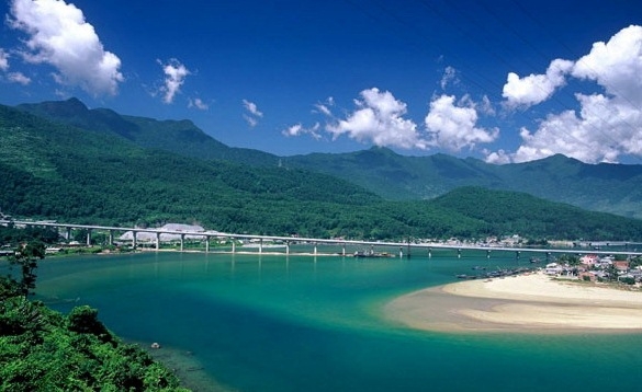
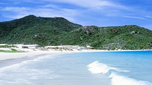
2. Lang Co Bay (Thua Thien – Hue)
Lang Co Bay, Phu Loc district is a potential place due to the nature and beautiful scenery. Above the bay is Hai Van moutain pass, mountains stretch away to the edge of sea. Below the bay is Lang Co beach with a stretch of white-sand and blue seawater.
Lang Co is a peaceful and primitive beach with a stretch of smooth white- sand and a blue and clear sea. Now, Lang Co Bay is officially the 30th member of World bays Club.

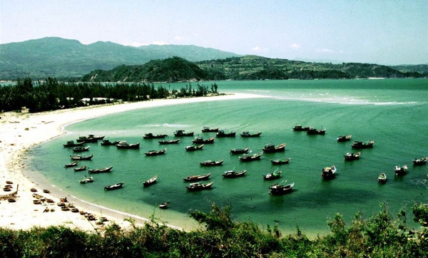
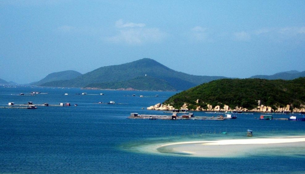
3. Xuan Dai Bay (Phu Yen)
Travelling about 45 kilometers to the north of Tuy Hoa city, Xuan Dai will appear as a water-color painting. The Bay is created by a range of mountains stretching away 15kilometers to the sea. It is like a head of unicorn.

Xuan Dai Bay has a variety of terrain. Rapids follow puddles, puddles follow beaches, beaches follow mountains, stretching endlessly. Xuan Dai has plenty of mountains, islands and peninsulas. All of them bring primitive beauty.

The other distinct character of Xuan Dai is smoothly white sand. In the nominated list of the most beautiful bays in the world, Xuan Dai bay is one of the tourist attractions in Phu Yen.

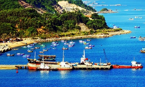
4. Vung Ro Bay (Phu Yen)
Vung Ro bay comprises 1,640 hectares of water surface with fascinating landscape which is ideal for sightseeing and swimming. There is a lot of seafood and and colorful coral reefs in the seabed of Vung Ro and services of fishing, swimming and diving.

Peninsulas cover Vung Ro, making it a good harbour for ships to anchor, to avoid storms and to fish. Vung Ro is shielded in the north, the west and the east by 3 ranges of mountain Deo Ca, Da Bia and Hon Ba. The south is seaport and Hon Nua island that is 105 meters in height and is like a fortress to guard vessels.

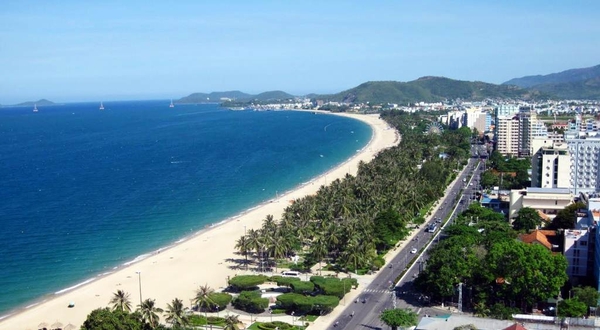
5. Nha Trang Bay (Khanh Hoa)
Shielded by 19 large and small islands, Nha Trang bay is out of wind without big waves. In Nha trang, there are almost 10 islands of salangane. Exploiting salangane’s nest gives Khanh Hoa province sale of million dollars annually. The other exciting world under the surface of Nha Trang bay is the world of 350 species of coral, 190 species of fish, mollusk, crustacean, sea grass…
Regarding to the ecosystem, Nha Trang bay is one of rare natural system of  beaches and bays in the world because it has almost typical and rare ecosystem of tropical beaches. That is wetland ecosystem, coral reefs, mangrove forest, sea grass cover, estuarine ecosystem, island ecosystem, coastal sand ecosystem.

In July 2003, Nha Trang bay, together with Ha Long bay, is officially recognized as one of 29 most beautiful bays in the world.

6. Van Phong bay (Khanh Hoa)
Van Phong is in Van Ninh district. From Nha Trang, it is about 80 kilometres to the north. There is a variety of the terrain of the bay, especially the system of islands, peninsulas, deep bays, attractive sand dunes. The bay has the diverse ecosystems such as tropical forests, mangrove forests, coastal flora and fauna.

In recent years, Van Phong bay has attraction of domestic and international researchers and tourism operators.

7. Ninh Van bay (Khanh Hoa)
Ninh Van is a beautiful island located in the community of Nha Trang bays, in Hon Heo peninsula, Ninh Hoa district, Khanh Hoa. The landscape in Ninh Van  unchanges in comparison with the natural and primitive scenery. Ninh Van is like a peaceful heaven with high mountains, and the forest stretching as far as the eye can see.


The smoothly white sand, turquoise blue sea or exciting coral reefs are main factors attracting visitors to go to Ninh Van. You can only see small wooden houses in the seaside, in rocks or in hillside here…
 
8. Cam Ranh bay (Khanh Hoa)
From Nha Trang city, travelling about 60 kilometers to the south, you will arrive Cam Ranh bay. The bay is immense and tranquil in the color of blue. In the bay, there are many coral reefs and flocks of colorful fish, which attract people having passion on scuba diving.

Beautiful beaches with lines of high coconut trees feature the central coastal region. Cam Ranh bay is an ideal place for international sea tourism such as: boating, fishing, diving and seeing coral reefs, relaxing, treating, climbing mountain…and is in no way inferior to anywhere in the world.

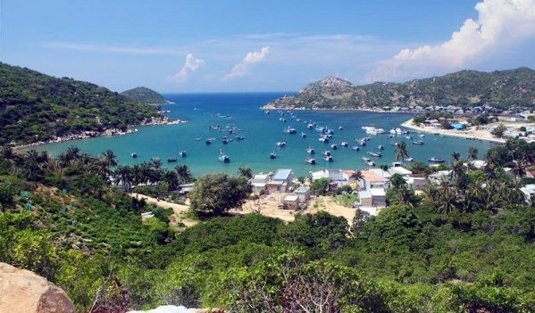
9. Vinh Hy Bay (Ninh Thuan)
Located in Vinh Hy village, Vinh Hai commune, Ninh Hai district, Vinh Hy Bay is about 40 kilometers from the centre of Phan Rang city. Vinh Hy Bay is surrounded by rocky mountains with mysterious caves. Vistors can enjoy clear atmosphere and watch flocks of fish swimming around boats in the blue seawater.
Vinh Hy is a charming picture. In the picture, life of people here and the short stop of visitors are sketchy lines, which make the picture more fascinating. In the journey, tourists will spend time on visiting and feeling the simple and wonderful gift of nature in the central Vietnam.

10. Ha Tien Bay (Kien Giang)
Ha Tien Bay has 105 large and small islands. One of them is Hon Nghe island where fish-breeding  is developing, and there are many tourist attractions.


Nature bestows on Ha Tien a harmony of landscapes: mountains, sea, islands and delta combined to form a picturesque land. Ha Tien Bay attracts almost visitors going to Mekong delta due to the breathtaking landscapes and a lot of specialities.

 Source:vietnamtourism.org.vn


Kim Hy Natural Reserve - Bac Kan

Location: Kim Hy Natural Reserve is located in Vu Muon, Cao Son communes in Bach Thong District and Luong Thuong, An Tinh, Con Minh communes in Na Ri District, Bac Kan Province
Characteristic: With area of over 14,000ha, the natural reserve has hundreds of rare flora and fauna species which must been managed and protected closely.  

Kim Hy is assessed as the reserve of primeval nature by Vietnamese and foreign scientists with hundreds of rare flora and fauna species. Among them Presbytis francoisi francoisi, squirrel, monkey are endangered species all over the world. Specially, visiting Kim Hy Natural Reserve, you will see diversity of bat species reputed most species in Vietnam. In addition, the natural reserve is large valuable wood-store of Bac Kan Province with hundreds of thousands of nghien, lat, dinh trees, mountain pine…

Kim Hy is also home to endangered flora species such as stone-pine (thiet san gia) which is only present at 4 mountainous provinces of North Vietnam and 2 provinces of Guangdong, Guangxi (China). Besides diversified fauna and flora, the Kim Hy Natural Reserve is abundant in minerals, especially gold.


Phuong Hoang Cave and Mo Ga Stream - Thai Nguyen

Location: The cave is located atop Phuong Hoang (Phoenix) Mountain, 45km from Thai Nguyen City along National Road No. 1B in the Thai Nguyen-Lang Son direction.
Characteristics: The cave includes 3 layers: the upper layer is Doi (Bat) Cave, the central is Sang (Light) Cave, and the lower is Toi (Dark) Cave. 


Visitors spend around half an hour climbing up to the cave. Seeing from its foot, the mountain has the shape of two laying phoenixes. Legend goes that a long time ago, there were a couple of phoenixes living very happily and they were born two eggs. Everyday, the father bird looked for food and the mother bird sat the eggs. One day lured by a new flock, the father bird forgot his task and did not come back. Until he remembered his task and returned to the nest, his wife had been transmuted into a rock. Feeling regrettable, he laid on the opposite mountain, looking toward the nest with the hope that his wife could revive. Waiting hopelessly for a long time, he was also transmuted into stone. Since then the mountain has been named Phuong Hoang (Phoenix).
Reaching the mouth of the cave, visitors can see the landscape of this land. The Light Cave is spacious and well-ventilated. The stalactites in the cave glitter fancifully thanks to the light from the three main mouths of the caves. Visitors can freely imagine the forms of these stalactites such as a mother is carrying her son on her back on the way to the field, ancient people are hunting wild animals, and lanterns.


At the foot of the Phuong Hoang Mountain, there is Mo Ga (Chicken�s Beak) Stream Cave. Its entrance is 100m wide and there is a stream that flows out from the cave. In front, there are many small waterfalls, bathing places, rocks, and small rocky islands. The water is clear and the landscape is fantastic.
 
The Phuong Hoang Mountain is the most beautiful in Thai Nguyen with the imposing landscape and beautiful cave. The site attracts many visitors. Phuong Hoang vestige and the stream in Mo Ga Cave were listed as National Sites by the Government in 1994. 


Dong Van Karst Plateau Geo-park - Ha Giang

Location: Covering the entirety of the four mountainous districts of Ha Giang Province, including: Quan Ba, Yen Minh, Meo Vac and Dong Van. 
Characteristic: Dong Van Karst Plateau is the first geological park of Viet Nam recognized as a member of the Global Geo-parks Network by GGN.  


From Ha Giang City, visitors travel on National Highway 4C for 43km to Quan Ba. Continuing on this highway through Can Ty Pass, pine forests, steep drops, deep ravines, and razor sharp turns, visitors will reach to the karst plateau.

Located on an altitude of 1,000m-1,600m, the 2,350km - Dong Van Karst Plateau is one of Viet Nam's special limestone areas, housing prominent imprints that depict the development of the earth's crust. Up to 80% of the karst formations of Dong Van Plateau are limestone formed by environment conditions and different development stages of nature. 
A survey conducted by scientists from the Viet Nam Institute of Geosciences and Natural Resources revealed the finding of 11 fossil - geological formations in Dong Van, including Chang Pung, Lutxia, Sika, Lang Xang, Si Phai, Toc Tat, Lung Nam, Bac Son, Dong Dang, Song Hien and Hong Ngai. Of which, Chang Pung is the oldest one with date of 545 millions years. In addition, 17 paleontology groups were also discovered in Dong Van, including Brachiopoda (Tay cuon), Trilobita (Bo ba thuy), Gastropoda (Chan bung), Foraminifera (Trung lo), Cephalopoda (Chan dau), Crinoidea (Hue bien), Tentaculies (Vo non), Conodonta (Rang non), Tabulata (San ho vach day), Tetracoralla (San ho bon tia), Stromatoporoidea (Lo tang), Spirulina (Tao), Bryozoans (Dong vat dang reu), Bivalvia (Hai manh vo), Hydrilla verticillata (Thuc vat thuy sinh), Sclerotesta (Vo cung), Polybranchiaspis liaojiaoshanensis (Ca co). The paleontology groups have helped scientists draw a complete picture of development history in terms of geology of Dong Van Karst Plateau in particular and northeast Viet Nam and south China in general. 


Thanks to weather changes and Dong Van's geo-diversity, the karst evolution has created "rock gardens" and "rock forests" of diverse forms in the area, such as Khau Vai rock garden (Meo Vac) where you can contemplate the peaks of rocks in the shape of different kinds of flowers, Lung Pu rock garden (Meo Vac) with animal-shaped rocks such as tiger and dragon, Van Chai rock garden (Dong Van) with round flagstones arranged like thousands of black sea lions leaning one another getting some rest on the beach. However, found commonly here are ranges of mountains running one after another to form pyramids heading up to skies. A system of caves and grottos found in the Dong Van Plateau provides a proof of the evolution of karst with Rong Cave in Sang Tung (Dong Van), Kho My Cave in Tung Vai (Quan Ba), En Grotto in Van Chai (Dong Van)...

The scientists have evaluated Dong Van Plateau as having a unique and diverse mountainous geo-ecosystem. Primitive forests here have been rather undamaged, habiting many rare floral species, including Burretiodendron hsienmu (Nghien), Taxus Wallichiana Zucc (Thong do), Amentotaxus hatuyenensis (De tung soc nau), Cephalotaxus hainanensis (Dinh tung), Podocarpus pilgeri Foxw (Thong tre la ngan), Cupressus funebris (Hoang dan ru).., especially over 40 species of orchids. Dong Van Plateau also has a rich diversity of habitat for fauna as scientists have spotted over 50 species of wild animals, birds and reptiles in the site such as Capri conrnis sumatresis (Son duong), Rhinopithecus avunculus (Vooc mui hech), Sus cristatus (Lon rung), Garrulax canorus canorus (Hoa mi)...


Besides geological, geomorphology and scenic values, Dong Van Karst Plateau reflects traditional cultural richness of 17 ethnic minority groups, such as Mong, Dao, Lo Lo, Tay, Nung... These ethnic minorities have lived with the rocks. Here, the rock gardens dotted with green corn fields and golden rice fields. In addition Pho Bang, Dong Van, Lung Cu, Sa Phin markets coupled with time-honoured ethnic festivals, rituals, customs and culture of local inhabitants weight the plateau's unique charm.
Visiting Dong Van Plateau in the spring, you are hit by wonderful landscapes composed by yellow cai (kale) flowers and pink peach flowers in full blossom, mossy tiled roofs of stilt houses, dark green rocks and blue skies. Far in deep valleys covered by pure white plum flowers in full blossom hear remote sounds of khen (pan-flutes) of Mong people. The season covers rugged rocks and mountain peaks with its bright colors.

On October 3, 2010, in Lesvos (Greece), Dong Van Karst Plateau was recognized as official member of Global Geo-parks Network (GGN) for its prominent values on landscape, palaeobiology, geology, geomorphology and local culture. Dong Van Karst Plateau has become the first geo-park of Viet Nam and the second one in Southeast Asia (after Langkawi Geo-park in Malaysia).   


Ninh Binh City Introduction

Ninh Binh is about 90 km away from Ha Noi to the south. Ninh Binh is located on Red river delta with geographical co-orrdinate from 19050' to 20027' at Northern latitude and from 105032' to 106033' at Eastern longitude. Ninh Binh shares the administative border with Ha Nam in the North, Nam Dinh in the East, the East Sea in the Southeast, Thanh Hoa in the West and Southwest, and Hoa Binh in the Northwest.

With over 1,400km2 of natural area, Ninh Binh has forests, sea and a diverse system of fauna and flora. Ninh Binh topography encompasses plains and the mountains of the Vietnam northwest mountain range. Ninh Binh also keeps a strategic position for military security and social development. Here, troops were usually rallied on their way to the north or south of Vietnam, creating famous victories in Vietnamese national history.

Ninh Binh is endowed with many places of particular interest which have been welknown inside and outside Vietnam such as Tam Coc – Bich Dong, Cuc Phuong National Park, Trang An Grottoes and Van Long Nature Reserves. There are also many historical relics, for instances Hoa Lu Ancient Capital, Bich Dong Pagoda, Thai Vi Temple, Phat Diem Stone Cathedral, Tam Diep Defense Line.... All of them are attractive to both Vietnamese and foreign tourists. Ninh Binh is the charming land of myth and unique landscapes.


Ninh Binh’s topography comprises three different types of landscapes: wetlands, coastal delta, hills and mountains. With such a variety of landscapes, Ninh Binh offers many tourist attactions as primitive rain forest, mountains, hills, river delta and the coastal delta. Furthermore, Ninh Binh is endowed with numerous historical relics dating back to the Dinh, Early Le, Ly and Tran dynasties from the 10th-13th century. Anually, Ninh Binh has many traditional festivals reflecting the cultural identites of Red river delta villages.
 

With a deeply rooted history and cultural tradition, the people of Ninh Binh are traditionally very industrious, hard working, studious, kind, patriotic and particularly hospitale.
Most tourist attractions are situated within a radius of 50km from the provincial city of Ninh Binh and the linking with all major transport systems as the national highway No 1A and the South – North railway.... Therefore, long distance busses and trains from Hanoi to Hue, Ho Chi Minh city and vice versa stop here making Ninh Binh an ideal place to spend several days relaxing.

Phu Quoc Island - Kien Giang

One of Viet Nam's star attractions, mountainous and forested Phu Quoc is a splendid tropical getaway set with beautiful white-sand beaches and quaint fishing villages. Adventure comes in many forms here – from motorbiking the empty dirt roads circling the island to sea kayaking its quiet inlets, scuba diving the coral reefs or simply having a bang-up seafood meal followed by a cocktail on the beach. Once a sleepy, backpackers’ retreat, Phu Quoc has ramped up tourism significantly, and visitors can now choose between five-star resorts and rustic family-run bungalows. Plans are underway for developing the island even more heavily – a la Phuket style. If package tourism isn’t your bag, get there now before this happens.

The tear-shaped island lies in the Gulf of Thai Lan, 45km west of Ha Tien and 15km south of the coast of Cambodia. At 48km long (with an area of 1320 sq km), Phu Quoc is Viet­nam’s largest island and its most politically contentious: Phu Quoc is claimed by Cam­bodia; its Khmer name is Ko Tral – which is why the Vietnamese have built a substantial military base covering much of the northern end of the island (thankfully, the military presence is fairly invisible). 


Phu Quoc Island served as a base for the French missionary Pigneau de Behaine during the 1760s and 1780s. Prince Nguyen Anh, who later became Emperor Gia Long, was sheltered here by Behaine when he was being hunted by the Tay Son Rebels.

Phu Quoc is not really part of the Mekong Delta and doesn’t share the delta’s extraordinary ability to produce rice. The most valuable crop is black pepper, but the islanders here have traditionally earned their living from the sea. Phu Quoc is also famous in Viet Nam for its production of high-quality fish sauce (nuoc mam).
The island has some unusual hunting dogs, which have ridgebacks, curly tails and blue tongues and are said to be able to pick up their masters’ scent from over 1km away (the nuoc mam their masters eat certainly helps). Unfortunately, the dogs have decimated much of the island’s wildlife. 

Despite the impending development (of a new international airport, a golf course and a casino), much of this island is still protected since becoming a national park in 2001. Phu Quoc National Park covers close to 70% of the island, an area of 31, 422 hectares.

Phu Quoc’s rainy season is from July to November. The peak season for tourism is midwinter, when the sky is blue and the sea is calm; however, when it’s not raining it’s stinking hot. Bring sunglasses and plenty of sunblock. Take plenty of water when setting out to explore the island.

The complex of historical sites and beauty spot of Bai Tho Mountain - Halong City

Nui Bai Tho or Bai Tho (means Poem) mountain is 610ft (186m) high. It runs along the coast of Ha Long Bay, half on land and half in the sea. In the old day, sailing in the bay, one or two hundred meters from the mountain, one can see a poem carved on a flat stone cliff, but now the view is blocked with houses.

In 1468, during his inspection tour to the eastern region, King Le Thanh Tong stopped here. Inspired by the stunning beauty of Ha Long, the King wrote a poem and had it carved into the southern side of the mountain, hence its name Bai Tho (Poem). In 1729, Lord Trinh Cuong composed a poem in response to that of King Le Thanh Tong and also had it carved near the former. The mountain features other poems by Nguyen Can and some other poets.
Atop Bai Tho Mountain, you feel surprised at the magnificent landscape of Ha Long Bay. In the background of immense emerald waters, of rock bobbing, of high sky, of surrounding flowers and trees, you can figure out the tiny images of boats. Bai Tho makes up one of the beauty spots of Ha Long.

Tran Quoc Nghien Temple
The temple is situated in an elevation at the foot of Bai Tho Mount, in the area of Ben Doan – Hon Gai, Ha Long City, Quang Ninh Province, looking to the sea.


The temple is dedicated to Tran Quoc Nghien, one of Tran Hung Dao’s sons and a brave, talented general in the resistance against the Yuan-Mongol invaders.
Tran Quoc Nghien was also famous for his filial piety, and Bai Tho Mount together set up a temple dedicated to him.
The temple has a three-compartment Ceremonial Hall, and a Back Sanctuary. The Holy Mother Temple lies to the right of the main temple. Inside the main temple, the middle altar is dedicated to Tran Quoc Nghien. The other two altars on the right and left sides are dedicated to the First Lady and Second Lady respectively. The Temple has a set of eight ornamental weapons, and various worshipping objects. It has undergone many restorations.
The captivating Temple is also famous for its sacredness. It has become a tourist destination in Ha Long City.

Long Tien Pagoda
 The pagoda is situated at the foot of Bai Tho Mount in the Long Tien Street, near Ha Long Market, in Quang Ninh Province.
Built in 1941, Long Tien is the biggest pagoda and a well-known historical place in Ha Long City

.

The pagoda has original and unique architectural style of the Nguyen Dynasty. Atop the three-gate entrance stands a statue of Buddha in a sitting position. Below is a bell tower, featuring three words Long Tien Tu (Long Tien Pagoda), flanked by two parallel panels. The main altar is dedicated to Buddha. The altar on the right worships generals of the Tran Dynasty, while the altar on the left is dedicated to the Holy Mother of Three Palaces.
It is very convenient for tourists to come there as the pagoda lies in the heart of Ha Long City. In the past, the festival of Long Tien Pagoda opened on the 24th day of the third lunar month. At present, every day is a festival. Tourists and Buddhist followers from near and far visit the pagoda for sightseeing, or presenting their offerings to Buddha. The pagoda gets extremely crowed on the 1st and the 15th day of each month and during Tet traditional holiday.